Prock...out
Thursday, July 23, 2009
We're in jasper!
....but no internet at the hotel.... Bummer. Jasper has really changed since i was here last 20 some years ago. We'll post up proper tomorrow from medicine hat.
Tuesday, July 21, 2009
Da Bears

P-Rock - Blown to Smithereens
Day 21 - Bell 2 Lodge, BC to Smithers, BC via Stewart, BC and Hyder, AK
View Larger Map
This day co
 uld not have been better. I know Blackie and I continue to write a blog full of superlatives, but - and incredibly so - each day just seems to get better. Today we started out from the Bell 2 Heliskiing Lodge in BC - about 1/2 day ahead of schedule. Our plan was to stop in and see Stewart, BC and H
 yder AK. Hyder is known as the most southern city in Alaska - and pretty much looks like a wild west town. What we learned from the Canadian Customs officer is that Hyder has NO - and I mean NO law enforcement. There is no local constable, there is no state police presence, and if law enforcement is needed the RCMP (Royal Canadian M
 ounted Police) in Stewart have been granted authority to cross the border to handle matters in Hyder until Alaska State Police can fly in (by float plane) to Stewart from some 120 miles away. It really and truly appears that Hyder has been completely abandoned by both the United States and the State of Alaska. Amazing. In fact, there is no US Customs requirement to enter Hyder! You have to pass through the Canadian station on the way out, but as far as the US is concerned, this isn't territory to be protected.
So after a nice lunch in Stewart, Blackie and I went into Hyder and took a look around. Really not a whole lot to see in town, mind you. First, there's t
 he "Bus", which reportedly has the best seafood anywhere. Anyone in Hyder will tell you that. Then there's the Glacier Inn - which is famous for "Hyderizing" anyone who wishes to do so. Yours truly and
 Blackie did this deed, of course. It involves doing a shot of 151 proof Everclear Grain Alcohol, with the stipulation of "No Sipping, No Smelling, and No Backwash" - We both were able to handle that assignment with all the Pennsylvania grace and honor we could muster.
Then we went
 up into the Tongass National Forest, which is famous for it's Salmon Run and the bears that fish there. We talked with several people that had been there for weeks - YES - WEEKS - in Hyder and had only seen a few bears. Well we got to see three of them. The first grizzly was fishing from a distance from the viewing deck and didn't give us good photo ops. However then a black bear and a grizzly bear (both apparently 3 year olds
  or so... the 'bottom of the barrel' in bear heirarchy) decided to stroll down to check out the salmon. Well the black bear caught wind of the grizzly at the same time the grizzly caught wind of the black. Mr. Black hightailed it out of there and the grizzly just moseyed on around for awhile before making his exit. It was quite thrilling to see, and we would have missed this second scene except the rangers held us up from leaving because they were crossing the road. Pretty cool stuff if you ask me.
We then proceeded on down to Smithers, BC which is on the Yellowhead Highway. Not a lot to report there, other than the scenery continues to be spectacular. I have no idea how many Glaciers we saw today, but it was a lot.
Tomorrow, on to somewhere east, we're really not sure yet.
P-Rock - GO BEARS!
Blackie Blog Day 20/21 - Some Fine Days
Combination post today - our purloined Internet connection last night at the HeliSki place degraded to unusable early in the evening.
Yesterday, today - BEST RIDING SCENERY YET! The Cassiar Highway is incredible - hard to keep the Beemo-potomai between the lines while riding through the valleys, gorges, along the rivers, glaciers. Of course it rained a bit both days, but that didn't matter. This was incredible - I hope the video I shot works out. High mountain waterfalls are common, huge glaciers are common.

We had to stop at this one on the way to Stewart/Hyder - we learned later at lunch in Stewart that the film Insomnia was filmed here (Robin Williams, Al Pacino) - if you remember the spooky scene in the fog at the end with the cabin - it was here.


We got lucky with the bears too (see the SmugMug site for more) - the Salmon run had begun, so the bears were coming in:

Yesterday, today - BEST RIDING SCENERY YET! The Cassiar Highway is incredible - hard to keep the Beemo-potomai between the lines while riding through the valleys, gorges, along the rivers, glaciers. Of course it rained a bit both days, but that didn't matter. This was incredible - I hope the video I shot works out. High mountain waterfalls are common, huge glaciers are common.

We had to stop at this one on the way to Stewart/Hyder - we learned later at lunch in Stewart that the film Insomnia was filmed here (Robin Williams, Al Pacino) - if you remember the spooky scene in the fog at the end with the cabin - it was here.


The Cassiar is flanked by at least 3 ranges, and each range has a distinct color and shape. We took a side road to Stewart BC/Hyder Alaska (gorgeous ride), and got to backtrack back to the Cassiar. Hyder is a VERY small town, isolated on the lowest portion of Alaska - no formal US border crossing going in from BC, but BC had one coming out. Three main objectives in Hyder - tour the town (done in 60 seconds), get "Hyderized" (our Hyderization was a lunchtime event), and see if the bears were out feeding on salmon on Fish Creek.

We got lucky with the bears too (see the SmugMug site for more) - the Salmon run had begun, so the bears were coming in:

For more bears, and other road pictures (including Hyderization), check out the SmugMug site:
We packed a lot in the last 2 days - good stuff. Time to crash.
Blackie out.
Monday, July 20, 2009
Wildlife - Next 10km

P-Rock- Soaking in the Hot Tub.
Day 20 - Whitehorse, YT to Bell 2, BC
View Larger Map
Yes, there really is a place called Bell 2, BC. It's a heli-skiing lodge and the only gas stop within 150 km in either direction on the Cassiar Highway. It's a place our friends Keith and Sally re
 ally need to get to. I'm posting some pictures of the room, which is set against the Ca
 nadian Rockies at a heli-skiing base north of Mezhadin (sp?) Junction. They have a wonderful outdoor hot tub and sauna and an excellent dining facility. Their on-site heli-skiing operation is called Last Frontier Heliskiing, and from the looks of this facility, must be first rate.
Today's scenery completely - and I mean COMPLETELY exceeded expectations. Blackie has that story for you. We blew past our planned stop of Dease Lake by 150km, hoping to try to get a day ahead of schedule in the next few days. Tomorrow we visit Stewart, BC and Hyder, AK and then continue South and East.

While on the Cassiar today, Blackie and I stopped for a great photo opportunity which I'm sure he'll post. However if you ask me, the signage says it all.
We saw some cool wildlife and then happened upon the Bell 2 just in time to collect dinner, a glass of wine and a soak in the hot tub. We're working on stolen internet, thanks to Blackie's having a ethernet cable with him. The lodge charges $27 for "internet access" with access control via the cable they give you. They should have known who they were dealing with!

In case you were wondering, I took a picture of a gravel (or pavement) break today. I know we've been using the term but haven't really shown you one. For the most part (except on the Taylor Highway, where Blackie and I surmised that they ran out of signs) they are well marked, b
 ut it's dicey whether they are hard-packed (that's good) or loose gravel (very, very bad). Today, these were mostly hardpack.
I will leave you with this photo, reminding you all that I take my photographs left-handed. What's wrong with this picture?
P-Rock- Exactly who IS in control here?
Sunday, July 19, 2009
Yukon Gold meets Pennsylvania Bold

P-Rock - North of 60
Day 19 - Dawson City, YT to Whitehorse, YT
View Larger Map
The PA boys left their permanent imprint on Dawson City last night. It seems that it was their annual music (read: drinking) festival, which was held at the local little league field. With all the rain the entire place was an absolute mudpit - just like most of the town. However
 Blackie and your P-Rock had to go check out the scene and add some PA color to this seemingly all-Yukon ev
 ent. It certainly had quite a crowd for a small tourist town at least 5 hours drive from everything. Before much time had passed, a ritual had started, face painting with the infield mud. Of course we did the deed, trying as hard as we could to not stand out like southern sore thumbs. It was a pretty raucous event, and frankly I don't really remember actually hearing much if any music. We heard it wa
 s over in one of the other tents, but we kinda never made it there. However the PJ's hat did make it's appearance on the beer tent.
The beer of c
 hoice was none other than Yukon Gold, brewed right in Whitehorse. It was a pretty good beer, although mass quantities make for a foggy morning. Trust us, we know.
Today's ride took us down the Sterling Highway to Whitehorse. It was 300 miles of what our hotel desk person described as "pretty good road with a couple of pavement breaks". Well that my friends was the Yukon Stretch. There were MANY pavement breaks, with two of them being something like 10km long. It also seemed to be motorhome/trailer caravan day. They were travelling in packs, so I'm thinking they may be going carnivorous.
 At any rate, they don't move over in the gravel and blow so much dust you can taste it inside the helmet while you have Visibility:Zero conditions. Not really a whole lot of fun. Of course all this was after we started out the day with about an hour's worth of rain showers... Canada just won't let up.
We made it into Whitehorse after 5pm and settled down to do laundry and have a nice plate of ribs for dinner. No beers for the boys tonight. Nope.
No phone service here tonight (again), so much for my ATT "Canada" plan. Tomorrow we head down to Dease Lake in BC, leaving another province (nee territory) behind. I am guessing that there will be no phone there either, but we are hoping for internet.
P-Rock - Panning for Gold.
Blackie Blog Day 19 - After the Gold Rush
More on Dawson City (Day 18 stopover) - a Klondike town known for gold strikes, saloons, sourdough, tough guys and tougher steaks (I had the latter for dinner). After settling in to the Triple J and washing off the road mud, we set about town.

It happens we rode into town during one of the biggest social events of the summer - the Dawson City Music Festival. The town was packed with merrymakers, most availing themselves of the saloons ahead of a trip to the festival. We dined at the Sourdough Saloon, where the drink of the night was the Sour toe (don't ask).

P-Rock is blogging the festival (or the beer garden next to the festival, which appeared to be the main event for 95% of the attendees). Pictured is a ad hoc drum band playing drums and 400 gallon oil tank.

Much fun, much mud. We have also come to believe that some derivation of the word Yukon must mean "Strong Ale". 
The Day 19 ride started ugly - mud and rain. We did eventually merit some asphalt, only to have it interrupted by the loosest gravel patches yet (not fun that). Add the blinding dust, and the ride was interesting (thankfully uneventful - Szak - the bells are working great). We finished with a decent roll into Whitehorse with a nice cloud-mottled sky. Noticed the GPS directions during the trip, and had to post - the picture is not great, as the road was shaking the GPS quite a bit - the top bar reads "2 to 1" - not sure if Garmin was giving me directions, or odds of survival given the road conditions.

Tomorrow, leaving "Strong Ale" for BC. For more pics, check out the SmugMug site:

It happens we rode into town during one of the biggest social events of the summer - the Dawson City Music Festival. The town was packed with merrymakers, most availing themselves of the saloons ahead of a trip to the festival. We dined at the Sourdough Saloon, where the drink of the night was the Sour toe (don't ask).

P-Rock is blogging the festival (or the beer garden next to the festival, which appeared to be the main event for 95% of the attendees). Pictured is a ad hoc drum band playing drums and 400 gallon oil tank.

Much fun, much mud. We have also come to believe that some derivation of the word Yukon must mean "Strong Ale".
The Day 19 ride started with breakfast just outside Dawson City - saw this poster on the entrance wall. We passed the Top Of The World Golf Course sign on the way into town (on the side of a fairly steep mountain), but did not see the course. Looks like we missed the midnight tourney by a few weeks.

The Day 19 ride started ugly - mud and rain. We did eventually merit some asphalt, only to have it interrupted by the loosest gravel patches yet (not fun that). Add the blinding dust, and the ride was interesting (thankfully uneventful - Szak - the bells are working great). We finished with a decent roll into Whitehorse with a nice cloud-mottled sky. Noticed the GPS directions during the trip, and had to post - the picture is not great, as the road was shaking the GPS quite a bit - the top bar reads "2 to 1" - not sure if Garmin was giving me directions, or odds of survival given the road conditions.

Tomorrow, leaving "Strong Ale" for BC. For more pics, check out the SmugMug site:
Blackie out.
Saturday, July 18, 2009
Blackie Blog Day 18 - Dawson City, Here I Come...
Our last day in Alaska started in Tok - breakfast at Fast Eddy's. Subscribing to the two meals per day philosophy, I opted for the Mushers Omelette, with biscuits and gravy on the side. If you are ever in Tok, do breakfast at Fast Eddy's.

P-Rock is blogging the ride - my brief comments. The roads were bad almost immediately, even the ones we thought would be good - the paved stuff sometimes scarier than the rubble. We passed Chicken Alaska hoping for a quick photo, but passed it before we even knew we did. Just over the border, the weather got ugly - when riding the Top Of The World Highway, you are clearly several thousand feet closer to lightning. The "Highway" is gravel, except where it is deep gravel:

Weather cleared as we hit Dawson City:

The descent from the Top Of the World into Dawson City was steep and interesting, with great views of the Yukon River (no pictures - this was 2 handed driving). The road stops for the ferry crossing into town:

This town still looks like a Gold Rush town, down to the dirt streets, saloons, and hotels. We'll have something to say there tomorrow. Needless to say, the bikes we dirt/mud covered when we hit the Triple J Hotel. We both opted to leave them uncovered out in the rainstorm (it caught up with us) for a cheap wash.
Don't forget the SmugMug site with more pictures:
http://jrpimages.smugmug.com/gallery/8654567_ByKRt/1/594845151_3com5
Blackie out.
Thunder Road

P-Rock - Rockin' and Rollin' down Thunder Road
Day 18 - Tok, AK to Dawson City, YT
View Larger Map
Well this was certainly an interesting day getting here. Blackie and I departed from Tok around 10am local to head toward the Taylor Highway. The Taylor Highway heads north from the Alaska Highway at Tetlin Junction for about 70 miles up to the town of Chicken, AK. Today's (easy) follower participation is to tell us how the town of Chicken got it's name. Anyway, Chicken is a natural PJ's segway, but for reasons you will soon find out we did not stop for pictures.
When the Taylor gets to Chicken it continues north to the town of Eagle, which was de
 vistated by a flood this spring and is still recovering. However we were going to take the logical right turn to the very aptly named "Top of the World" (TOTW) highway to Dawson City. TOTW is about 130 miles long and crosses the Canada border about halfway between Chicken and Dawson. It is about 80% dirt road, and is a very scenic road running along a series of ridges on its route West. When you get to Dawson City there is no bridge across the Yukon River, so you have to take a ferry (free, mind you) to get to Dawson. Blackie will be telling you more about that and Dawson itself.
As we rode into Chicken we could see a growing storm to our west that was chasing us. Between it's movement and growth, we were losing the race, but decided to soldier on hoping to stay ahead of the storm. You see these dirt roads up here get VERY slippery when wet - locals like to describe it as "d
 riving on snot" - so we really wanted to have nothing to do with that.
We lost.
Now, mind you, the entire time we drove through Canada to get here we had rain every single day. And every day in Alaska was rain free. Well, within a kilometer of crossing the border Blackie and I had to stop to gear up for the now obviously-going-to-hit-us rainstorm. As you can guess between the race to stay ahead and the storm itself we lost out on some incredible picture opportunities, but I still have a few to share. Including one of our storm as we tried to stay ahead.


When the storm hit, it hit with fury - with hail, driving rain, and lightning - and I mean close no-time-between-light-and-sound lightning. Blackie and I pulled off and took what refuge we could until the worst had passed, then tip-toed toward Dawson. Unfortunately for me, Blackie was lead donkey today and about a mile from our refuge point we encountered the next ridge - and no rain. It hadn't even rained a drop. Now think about this - mix one we motorcyclist with one wet motorcycle with road dust from Blackie's tire. You get this:

After that we wandered down to the ferry where Blackie will pick up his story.
Oh, and it takes a re
 al manly man to ride in a full stand on a dirt road. I bow to his prowess.
P-Rock - Just remember I was one-handed taking that picture.
Yes, Motorcycles Make You Pee
 P-Rock, Biologically Correct
Day 17 - Seward, AK to Tok, AK
View Larger Map
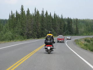
Today was a riding day. We had a total of 460 miles to trek from Seward, AK
 to Tok AK. Other than our finishing run through Ohio and PA, this is the most amount of backtracking we will be doing on this trip. Today we will do a total of 10 miles of backtrack, and on Monday we will have around 100, but other than the finish, that's it. I do have to say that this backtrack was some of the most scenic and beautiful, so well worth the re-hash. In particular, the travel around Turnagain Arm south of Anchorage is breathtaking.
Following that we had a nice ride down the Glenn Highway from Palmer to Glenellen, AK. It was a nice curvy twisty road that made for some good performance riding. A fun change. Blackie is detailing our stop at a Glacier, which was also very memorable. After leaving the glacier, we blasted up to Tok (this was another 4 hours of riding) and a very tasty dinner at Fast Eddie's. I think we'll be doing breakfast there before we leave town too.
So, anyway, on to the real topic of this blog, which is some of the "non sightseeing, non adventure" part of the trip. I had been thinking about this for a few days now, and after I talked to Mrs. Rock this morning she helped me gel this topic. She had asked me a few questions like these:
"How's the motorcycle? Is it comfortable?"
Well the motorcycle is awesome. The combination of performance - both engine and handling makes it quite a package. It literally is FUN to ride, and I mean this after almost 6000 miles in 17 days. I do not have the feeling of "Oh God, another day" yet, and I don't anticipate getting it. The first few days I was getting a bit of a tailbone ache at the end of the day but that is even gone. One thing you do, is learn a lot about shifting positions to keep any particular pressure point from bothering you. For instance, I tend to switch from upright riding, to a slouch with feet on the highway pegs (Dave, we hope you know what that means now? If not post up a comment and we'll shoot some pictures for you), to an upright posture with the feet on the highway pegs, bracing my butt off the seat. Then when I need a bigger change I will either sit up on the edge of the passenger pillion for awhile (This is more comfortable than you might think) or even stand straight up while riding through a small town (This is also a welcome change). If I had to rate he bike, I'd give it a 10 out of 10.
"Don't you get sick of riding every single day?"
No. We have something new to look forward to every day, and the things we've done on the spur of the moment (As my cousin Chuck said much earlier in a comment here) have been some of the most memorable. Our schedule changes and last minute re-routes add spice to this adventure. Riding is certainly not a chore. The ability to just be immersed in the environment is way cool. The sights, smells, and even at times the feeling (wind, rain, sun) enhance every mile.
"Do you miss home? Aren't you wanting to get back to where you can just open the cupboard and have a bowl of cereal?"
Most certainly so. I do miss home and my family, my job and co-workers, and absolutely look forward to the day we get back. But in the meantime I don't let that get in the way of having a great time while we're here. Today is our last day in Alaska and in some ways that's a downer - but we have lots more to see and do. And besides, it really isn't our last day in Alaska as we'll be spending a few hours in Hyder, AK (the southernmost town in Alaska) later this week. But now we will be heading to the Yukon today and back to Pacific Time - the first clear signal we'll be on our way home. So yes I do miss home.
Now for one other comment.
Motorcycles DO Make me Pee.
Blackie, it seems - not so much. Now mind you that at the risk of providing you with way more biology than you care to know I have never been known for the size of my bladder. In tavern parlance, I am a "one beer - one pee" person. But the motorcycle - I'm not really sure what - vibrations, bouncing, sitting position? - gives me what I call a 125 mile bladder. We regularly push this to up to 175 miles, even 200 a couple of times - but I get the calling sooner than we stop almost always. So it's something I deal with and Blackie has to tolerate (what other choice does he have when I'm stopping anyway?).
So today it's off to Dawson City, YT. Should be a great ride and we hear Dawson is a fun town. I am not sure of our internet access capabilities there, but hopefully we'll be posting up the damage tomorrow.
I will leave you with this follower participation question, which I just learned about in the Men's restroom at our hotel (I apologize for the restroom theme peeps). Funny how little things posted above a men's room facility get attention. At any rate, how did TOK get it's name, and What day is considered TOK'S celebration day?
P-Rock - Excuse me, I have to hit the Rest Room.
Blackie Blog Day 17 - Ice, Ice Baby
It was P-Rock's turn riding bell cow this afternoon when we passed by this sight - the Matanuska Glacier. Though we were pulling long miles today to make Tok, we both knew we had to turn back and visit this one.

No comments on the photo composition please - it is pretty good considering the motorcycle moving at 65MPH on mountain twists, shooting sideways.... It seemed pretty close, but the ride to the trail head was long and a bit ugly in spots for 1100 pound motorcycles. That said, it was worth the effort. The parking area sits close to the edge of the receding edge - from there you hike a 1.5 miles over the debris field and shed water to the glacier.

We overheard a guide say in season the glacier gains or loses 3 feet/day, so it looks different every day. As we approached, the temperature dropped steadily - probably 20F cooler at the edge.

No going further than here without ice climbing equipment, which several folks were doing. Had to get a Snuzzles on Ice picture for the record.

This was a worthy stop, even though it pushed our Tok arrival a bit late. The rest of the ride was great, especially the Tok Cutoff Highway - the last 60 miles into Tok were extraordinary - vistas, mountains and lakes. A quick Fast Eddy's dinner, and crash time.
One further note - I captured P-Rock executing a seventh inning stretch technique we have perfected on the trip - the stand-up stretch we can do now at highway speeds.
Will try to catch up with more photos on the SmugMug site:
http://jrpimages.smugmug.com/gallery/8654567_ByKRt/1/571278936_DfRP4
Day 18 - Top Of The World...
Blackie out.

No comments on the photo composition please - it is pretty good considering the motorcycle moving at 65MPH on mountain twists, shooting sideways.... It seemed pretty close, but the ride to the trail head was long and a bit ugly in spots for 1100 pound motorcycles. That said, it was worth the effort. The parking area sits close to the edge of the receding edge - from there you hike a 1.5 miles over the debris field and shed water to the glacier.

We overheard a guide say in season the glacier gains or loses 3 feet/day, so it looks different every day. As we approached, the temperature dropped steadily - probably 20F cooler at the edge.

No going further than here without ice climbing equipment, which several folks were doing. Had to get a Snuzzles on Ice picture for the record.

This was a worthy stop, even though it pushed our Tok arrival a bit late. The rest of the ride was great, especially the Tok Cutoff Highway - the last 60 miles into Tok were extraordinary - vistas, mountains and lakes. A quick Fast Eddy's dinner, and crash time.
One further note - I captured P-Rock executing a seventh inning stretch technique we have perfected on the trip - the stand-up stretch we can do now at highway speeds.

Will try to catch up with more photos on the SmugMug site:
http://jrpimages.smugmug.com/gallery/8654567_ByKRt/1/571278936_DfRP4
Day 18 - Top Of The World...
Blackie out.
Subscribe to:
Posts (Atom)


